
Rollinsville Plan
We want to hear from you!
Gilpin County and JVA are working together on the Rollinsville Infrastructure Study and Area Specific Plan, and your voice will help shape the outcome.
📅 Public Meeting Schedule
- Virtual: Wednesday, Oct. 1 at 6:00 p.m.
🔗 Join via Zoom
Meeting ID: 865 2579 6147 · Passcode: 212552 - In-Person: Thursday, Oct. 9 at 6:00 p.m.
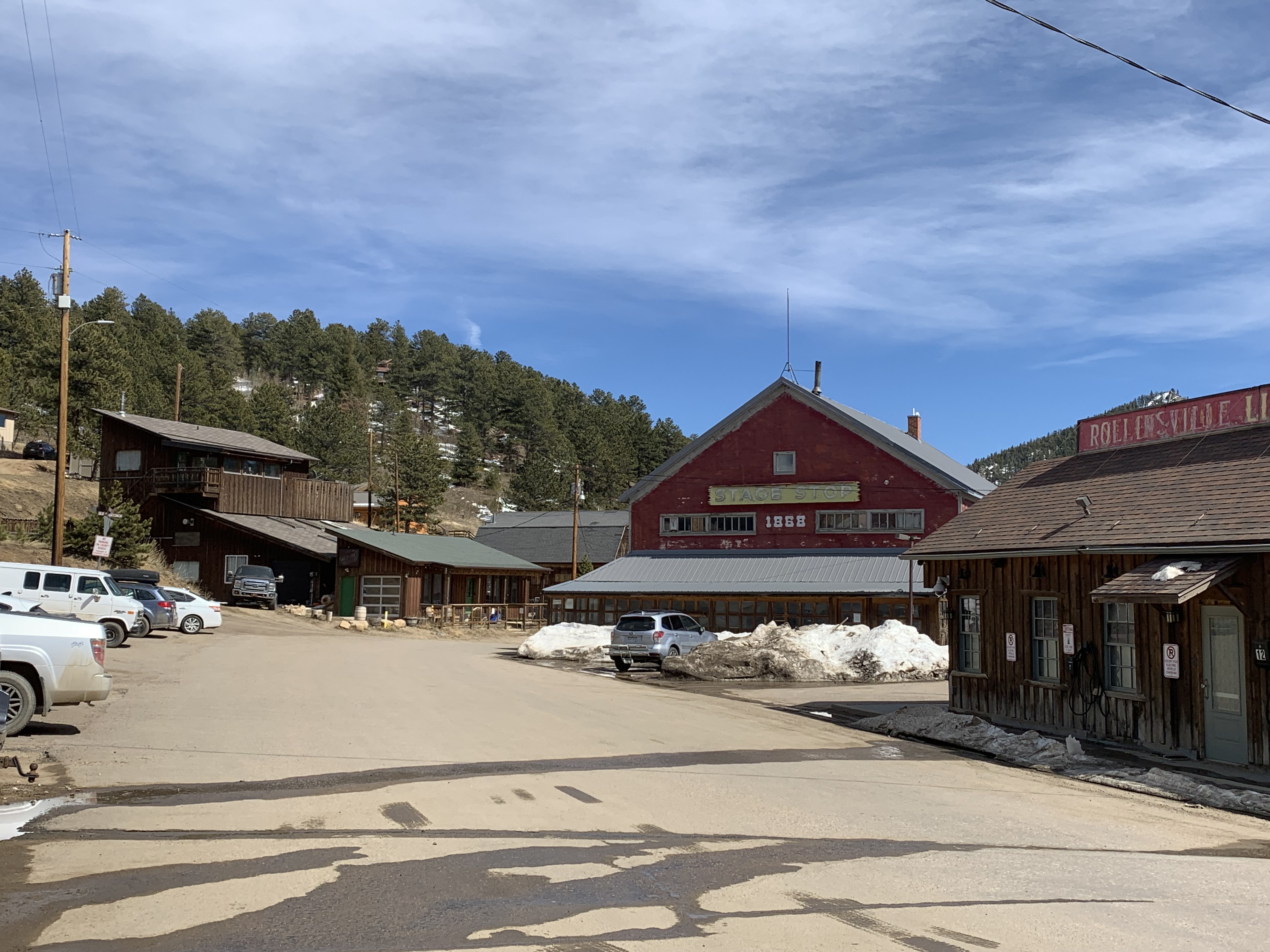
📍 Howlin Wind Brewing and Blending · 51 A Main St, Rollinsville, CO 80474
At these meetings, the project team will share updates on the draft plan and gather community input on Rollinsville’s future. We want to know what matters most to you — from land use and preservation priorities to potential infrastructure improvements such as a passenger rail stop, roadway and pedestrian connections, parking, water and wastewater treatment, and firefighting water supply.
Your participation is vital to shaping the path forward!
Under the Gilpin County Accessibility Plan (See 8 CCR 1501-11:11.5.D), and pursuant to 8 CCR 1501-11:11.5.C., Gilpin County will provide reasonable modifications or accommodations, when requested, to remove accessibility barriers (unless exempt under 8 CCR 1501-11:11.10) at no cost to the requestor.
Rollinsville is at a pivotal moment — facing real challenges, ongoing changes, and important opportunities. This study and area plan are about preparing for what’s already happening, not forcing change, but guiding it in a way that keeps Rollinsville safe, resilient, and true to its character.
Urgency: Safety, Stability & Stewardship
Some challenges can't be postponed any longer.
- Fire Protection - Rollinsville lacks sufficient firefighting water capacity. Without a shared solution, future development in the commercial core cannot move forward safely, and even existing business operations and homes are at a greater risk.
- Problematic Wells and Septic Systems - Many on-site wastewater systems are outdated, overburdened, while many wells are under-tested, potentially posing environmental and health risks.
- Roadway Safety - Dust, steep shoulders, limited parking, and speeding create hazards for residents, drivers, cyclists, and pedestrians.
Inevitability: Change Is Already Here
Whether or not we plan for it, change is happening.
- Tourism and Recreation - Visitor numbers continue to grow, bringing more vehicles, parking challenges, and environmental impacts — all straining limited local infrastructure.
- Housing Demand - Pressure from the Front Range is expanding into nearby mountain communities, driving up prices and reducing housing availability for local residents, while also prompting developers to find new sites to build.
- Aging Infrastructure - All infrastructure needs replacing eventually. Existing wells, septic systems, and roads will deteriorate without proactive investment and maintenance, with costs increasing over time.
Opportunity: Shaping a Stronger Future
We can shape outcomes instead of reacting to them.
- Economic Diversification - Rollinsville can better support local businesses and services, capture existing visitor spending, and help reduce reliance on gaming as the County’s primary economic driver.
- Mountain Rail - The proposed passenger rail line could create new connections, revenue streams, and accessibility if planned for thoughtfully.
- Collaboration - Coordinating infrastructure projects helps neighbors and agencies pool resources, avoid duplicated costs, and design systems that work together. It also positions the community to achieve what individual property owners typically can’t do on their own.
Questions received from members of the public and answered by County Staff and/or JVA Consulting Engineers
Population & Demographics
Q: Why does the population graph show a dip around 2015?
A: That appears to be an anomaly in the census data, but the team is interested in hearing from community members if they have any local context.
Q: Does the population number include both Zone 1 and Zone 2?
A: The population number reflects the Rollinsville Census Designated Place (CDP), as determined by the U.S. Census Bureau. While not a direct alignment with the Zones identified in the draft plan, this is the only real source for population data.
Water & Wastewater Infrastructure
Q: Regarding the brewery and distillery water usage figures, why are they so high compared to actual use?
A: JVA will follow up directly with the business owners to review and refine these figures.
Q: How do you get permission to cross private property for a water main?
A: Easements would be required.
Q: What does “107 taps” refer to?
A: It represents the maximum number of taps if every property within the service area chose to connect.
Q: Would property owners be required to connect to the system if the water service passes by their residence? What would the tap fee or per-gallon cost be?
A: There are no plans to require property owners to tap into the water system. Tap fees and per-gallon costs have not yet been explored as part of the feasibility study.
Q: Where will the water come from? If it’s taken from the stream, how will downstream users be handled?
A: This is one of the most significant hurdles. Downstream users include Denver Water and the City of Lafayette, both with senior water rights. A formal augmentation agreement would be required, which will be challenging.
Q: How many parcels are there in each zone, and how many are undeveloped?
A: Zone 1 contains approximately 125 parcels, 65 of which are undeveloped. Zone 2 contains approximately 185 parcels, 81 of which are undeveloped.
Q: If there is little residential demand for water and sewer, how would that affect system costs?
A: Residential demand is a major factor in how water and wastewater systems are designed, sized, and financed. If far fewer homes connect than anticipated, the system’s total capacity needs might shrink slightly, but the fixed infrastructure costs — like treatment plants, pumps, and distribution lines — remain largely the same. With fewer users to share those costs, the per-connection cost would likely increase.
Q: If you cannot acquire the necessary water rights, is the project canceled?
A: This would require further discussion with stakeholders. Alternative options, such as wells, may be explored.
Q: How would a special district affect property taxes?
A: It depends on how the County structures the district. Any new tax would require voter approval through a public process.
Q: What is the return on investment (ROI) per parcel based on the project’s estimated costs? Is it worth it?
A: Parcels differ in size, land use, and development status, and some property owners may choose to connect while others do not. System costs are based on capacity and infrastructure needs, not parcel count, and future funding sources like grants or low-interest loans could substantially lower the local share — so any “per-parcel” number today would be speculative and potentially misleading.
Transportation & Road Conditions
Q: How wide is Tolland Road?
A: Width varies between approximately 32 and 41 feet. Achieving consistency would require easements, right-of-way acquisition, or other agreements.
Q: How wide is a lane?
A: Around 12 feet.
Q: Do you intend to widen roads through eminent domain?
A: No, there are no plans to use eminent domain.
Q: How many trains per day are expected?
A: CDOT has not yet provided final information. The goal for the Winter Park Ski Train is to run five round trips per day when reservations warrant; They did a trial run this past ski season, but the train did not stop between Denver and Winter Park.
Q: How many parking spots would be needed for projected train ridership (25,000 people/year)?
A: There’s no requirement for 121 parking spaces — that figure simply illustrates how many could be created on the site if the community chose to pursue that scale. With projected ridership of about 55 passengers per day, a much smaller parking area — around 50 spaces — would likely be sufficient as a starting point, with the option to expand in the future if demand grows.
Q: Is having a rail station dependent on building water and sewer systems?
A: Likely not. However, a public restroom will likely be a requirement. JVA and County Commissioners and staff are looking into the minimum infrastructural components that will be required for the rail stations; more information about this should be available soon.
Q: Why isn’t the CDOT-owned property east of Highway 119 and south of town being considered for the station?
A: That site was evaluated by CDOT during its location analysis, but it was deemed not viable due to access limitations through privately held lots and other logistical challenges. The location currently under consideration was one of the three most promising sites identified in CDOT’s study, and JVA’s independent analysis supports that choice based on key factors like the length of space required for trains, site flatness, and overall suitability for the necessary infrastructure.
Q: Would it be possible to construct a very simple train platform with limited parking and no building?
A: Maybe. JVA and County Commissioners and staff are looking into the minimum infrastructural components that will be required for the rail stations; more information about this should be available soon.
Q: Will the train stop long enough to benefit local businesses?
A: It’s too early to know for sure how much local businesses will be impacted, since train frequency, schedules, and stop duration haven’t been finalized. The station is expected to be a smaller, quicker stop with lower ridership than major hubs, so how much local businesses benefit will likely depend on how well the community and individual business owners position Rollinsville as a destination worth exploring during a visit.
Q: How many vehicles travel along Tolland Road each day?
A: 16 individual traffic count assessments have been conducted so far throughout 2025. The lowest daily count was calculated at 249, while the highest was calculated at 1,001.